MilGPS
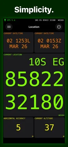
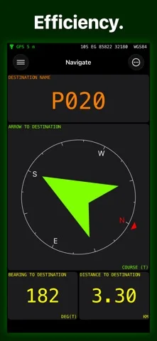
MilGPS displays field coordinates and waypoints in MGRS and other selectable formats.
For trained users needing a supplementary coordinate aid
Custom screens and GPX exchange support waypoint workflows.
Keep in mind: No route planning or track recording; not for military operations, live firing, aviation, surveying or any reliance risking injury/loss.
Inside the app
Official product images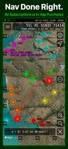
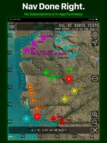
What you can do
- Display location in selected datums.
- Create/organize waypoint overlays.
- Import raster MBTiles and exchange supported waypoint files.
App Store review themes
Recurring praise and complaints, grouped by topic.
35 reviews · US App Store · Written feedback; review platforms are not identified
What reviewers like
Positions reviewers find useful in the field
4 reviewsReviewers report accurate locations for course checks, field work and plotted sites. One explicitly notes phone-sensor limitations; no independent accuracy test is implied.
See 2 review examples
The reviewer reports good results plotting gravesites but explicitly cautions that phone compass and position accuracy have limits; no universal five-meter bound is validated.
Original excerpt“seems to be spot on”Apple source · Review 14118034351
The reviewer reports accurate results in their use; this is not a safety or accuracy certification.
Original excerpt“very accurate every time”Apple source · Review 14092412812
Straightforward point and navigation workflow
4 reviewsReviewers appreciate a simple interface and easy point setup, adjustment and distance checks.
See 2 review examples
The reviewer finds point management and distance checks easy on land-navigation courses.
Original excerpt“Setting up and taking down points, adjusting spacing and verifying distances is all so easy.”Apple source · Review 14431039272
Importing, exporting and sharing
3 reviewsPositive feedback covers map overlay sharing (2 reviews); location information sharing (1 review).
See 2 review examples
The reviewer values sharing overlays.
Original excerpt“Share the overlay with colleagues”Apple source · Review 13804921486
The reviewer likes sharing information while hunting, without specifying the format.
Original excerpt“sharing info”Apple source · Review 13514403068
Show fewer positive themes
Coordinate grid formats
3 reviewsReviewers praise coordinate grid formats.
See 2 review examples
The reviewer values MGRS/grid output.
Original excerpt“pretty decent MGRS or grid locations”Apple source · Review 14118034351
The reviewer uses the app to help translate older map datums and grid references for communication.
Original excerpt“assist in the translation process”Apple source · Review 14085532525
Route planning
3 reviewsReviewers praise route planning.
See 2 review examples
The reviewer values trip planning.
Original excerpt“great for route planning”Apple source · Review 14719882970
The reviewer appreciates measuring and plotting routes.
Original excerpt“measuring and plotting routes”Apple source · Review 14233775287
Waypoint management
3 reviewsReviewers praise waypoint management.
See 2 review examples
The reviewer values waypoint marking and projection.
Original excerpt“marking and projecting waypoint locations”Apple source · Review 14233775287
The reviewer values tracking and sharing waypoints and coordinates.
Original excerpt“keeping track of and sending waypoints and coordinates”Apple source · Review 14222919129
Value and purchase options
3 reviewsReviewers praise purchase value.
See 2 review examples
The reviewer considers the purchase worthwhile.
Original excerpt“worth every penny”Apple source · Review 14509964784
The reviewer considers the purchase worthwhile.
Original excerpt“Well worth the small price”Apple source · Review 14182343022
Speed and responsiveness
3 reviewsPositive feedback covers map planning responsiveness (2 reviews); position acquisition (1 review).
See 2 review examples
The reviewer finds planning fast and reliable.
Original excerpt“fast reliable pre trip trip and port trip planning”Apple source · Review 14624268133
What reviewers dislike
More map drawing and symbol choices
5 reviewsReviewers request lines, boxes, graphical overlays or a wider range of symbols for custom planning.
See 2 review examples
The reviewer requests map drawing plus zones and icons.
Original excerpt“draw lines and trails”Apple source · Review 14509964784
The reviewer wants connecting lines and boxes.
Original excerpt“lines between points or even create boxes”Apple source · Review 14342183538
Good for
- Trained navigators using additional independent tools.
Consider alternatives for
- Anyone replacing safety-critical navigation equipment.
Limitations & considerations
- Captured minimum: iOS 26.0.
- No route planning or track recording; not for military operations, live firing, aviation, surveying or any reliance risking injury/loss.
Privacy & permissions
GPS use affects battery; Google map selection has separate data implications.
Sources & review notes Updated Nov 9, 2026
Reviewed by iApp4Me Editorial Team. Recommendations use the linked documentation and attributed accounts; device observations are identified separately.
- US App Store developer description
Complete description, download price and compatibility metadata captured 2026-11-02.
No comments yet. Be the first to share your experience.